Great scenic loop. It’s where we take all of our friends when they come to visit.
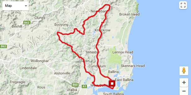
Total distance around 60km and 685m vertical.
From in front of The Bicycle Emporium head west out of town along River St. I usually go over the creek on the bike path and into Johnson Dr then Kalinga St to the end. Then right into Burns Point Ferry Rd and left at the roundabout. Out of town go under the motorway and then take the first right into Teven Rd (watch for traffic behind you).
Follow Teven Rd to the end, left then first right into Eltham Rd. Head past the Teven Golf Course, up the hill and down the other side, fast descent with a pick-a-plank bridge at the bottom! Over the next rise and bridge then right into Houghlahans Creek Rd. Follow that to Tooheys Mill Rd and at a threeway intersection veer right into Nashua Rd. Follow Nashua Rd to the end at Fernleigh above the school.
Turn left here onto Fernleigh Rd and down a big flyer – carry plenty of speed up the other side and you’ll almost make it!
Continue along Fernleigh Rd to Newrybar (maybe stop at the renowned Harvest Cafe). Left out of Newrybar onto the old Pacific Highway, now Hinterland Way, and then immediately right onto Broken Head Rd towards Byron Bay and up a short steep pinch, over the M1 motorway.
After a couple of kilometres, look for Old Byron Bay Rd on the right – just before the road heads downhill.
There is a GREAT photo opportunity at the top of the first little steep bit on Old Byron Bay Road that looks out over Lennox Head. Lean your bikes against the wire fence for a selfie!

Follow Old Byron Bay Rd to the end and turn left back onto Hinterland Way. There is good coffee on the right at the Byron Bay Wildlife Sanctuary (formerly the Macadamia Castle).
Continue along Hinterland Way to the Ross Lane on-ramp and along the motorway shoulder taking the next exit back into Ballina (there is a Strava segment on the on-ramp that ends after the road levels out.
Alternate route: Turn left at the Ross Lane roundabout and head down Ross Lane to Lennox Head and come back along The Coast Road.
You can download a GPX file direct from Map My Ride®, just follow the link below.
Leave a Reply
You must be logged in to post a comment.